European Union Flag and Map: A Visual Tool for Unity and Education
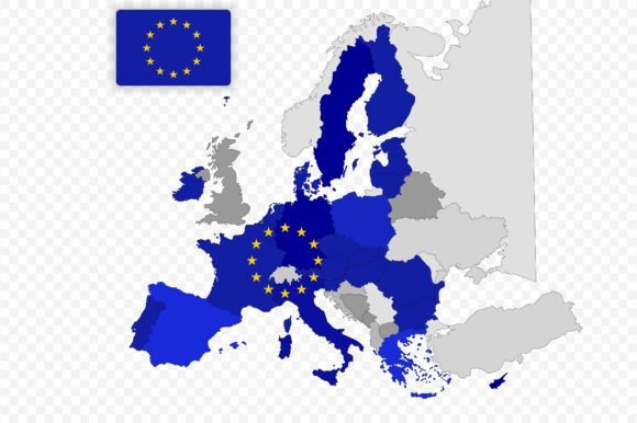
When you need to communicate the concept of continental unity, few visual elements carry as much weight as the European Union Flag and Map. This combination is more than just a graphic; it is a shorthand for decades of political cooperation, shared economic goals, and cultural exchange. For educators, designers, and content creators, having access to a high-quality, flat-style illustration that merges the iconic blue field with twelve golden stars and a clear political map of Europe provides a versatile foundation for countless projects.
The power of this specific design lies in its simplicity. By presenting the European Union flag combined with a political map in a flat style, the illustration removes unnecessary visual clutter while retaining essential geographical and symbolic details. This approach ensures that the message remains clear whether it appears on a small mobile screen or a large presentation board. It represents shared identity across Europe without getting bogged down in complex topographical details that might distract from the core theme of cooperation.
Why Flat Style Matters for Modern Communication
In today's digital landscape, clarity is king. The flat design trend has taken over because it scales beautifully and loads quickly. When you are working with a European Union Flag and Map, the flat style ensures that the boundaries between member states are distinct but not overwhelming. This makes it an ideal choice for geography education where students need to identify countries without being confused by 3D terrain effects or excessive shading.
For marketers and bloggers, this aesthetic fits seamlessly into modern web design. Whether you are creating a travel guide about the Schengen Area or a blog post discussing EU trade policies, the clean lines of a flat illustration integrate effortlessly with contemporary typography and color palettes. It avoids the dated look of clip art while remaining professional enough for corporate presentations.
Real-World Applications for Educators and Students
One of the most impactful uses for this resource is in the classroom. Geography teachers often struggle to find materials that accurately reflect current political boundaries while also highlighting the symbolic nature of the union. A fully editable vector file allows educators to customize the map for specific lessons. For instance, a teacher might highlight only the founding members of the EU in one lesson and then show the expansion over time in another.
Students benefit from seeing the connection between the flag and the land it represents. Instead of memorizing abstract shapes, they can see the physical space covered by the European Union. This visual link helps in understanding concepts like regional integration, cross-border collaboration, and the scope of European law. The ability to adjust colors means you can create interactive worksheets where students color-code different regions based on language families, economic zones, or historical alliances.
Empowering Travel Content and Tourism Campaigns
Travel writers and tourism boards constantly search for imagery that evokes a sense of adventure and connection. The European Union Flag and Map serves as a perfect backdrop for articles about backpacking through Europe, driving across the continent, or exploring the diverse cultures within a single political framework. It signals to the reader that the journey covers multiple nations under a unified system of travel freedom.
Imagine a travel blog post titled "Navigating the Eurozone." Using a custom version of this map allows the author to mark routes, currency zones, and key cities directly onto the illustration. Because the file is an EPS (Encapsulated PostScript) format, it remains crisp at any resolution. You can use it for a tiny icon on a website sidebar or blow it up for a full-page magazine spread without losing quality. This flexibility is crucial for travel guides that need to look professional across print and digital mediums.
Professional Presentations and Political Awareness
For business professionals, consultants, and policymakers, visual aids are essential for conveying complex data. When preparing a slide deck on European market trends or regulatory compliance, a generic map found on Google Images often lacks the polish required for a serious audience. The European Union Flag and Map offers a tailored solution that looks authoritative and well-researched.
You can open the EPS file in your preferred design software to adjust the layout specifically for your needs. Perhaps you need to emphasize the capital cities of member states, or maybe you want to overlay statistical data regarding GDP or population density. The vector nature of the file means every shape is independent and editable. You can change the color scheme to match your company branding while keeping the integrity of the EU symbols intact. This level of customization ensures that your political awareness materials or corporate reports stand out as bespoke rather than off-the-shelf.
Design Flexibility for Creators and Marketers
Freelance designers and social media managers know that versatility is the key to efficiency. Having a high-quality asset like this in your toolkit saves hours of creation time. Instead of drawing a map from scratch, you start with a solid base and adapt it. Whether you are designing a poster for a cultural festival, an advertisement for a study abroad program, or a banner for a news website, the underlying structure is already there.
The inclusion of a JPG preview image is also a practical touch. It allows you to quickly assess how the design will look before committing to editing the vector file. This is particularly useful when brainstorming ideas for European-themed graphics or when collaborating with clients who need to approve concepts rapidly. You can share the preview to get feedback on the composition before doing the heavy lifting in Illustrator or Inkscape.
What to Consider Before Using the Resource
While this resource is incredibly flexible, it is important to consider the context in which you apply it. Ensure that the political boundaries depicted align with the specific narrative you are telling. If your project focuses on historical events prior to certain expansions, you may need to modify the map to reflect the borders of that era. The editable nature of the EPS file supports this, but it requires a basic understanding of vector editing tools.
Additionally, be mindful of the symbolism. The European Union flag is a protected symbol in many contexts. While using it for educational, travel, and general informational purposes is standard practice, commercial applications should respect the guidelines surrounding the use of official emblems. Always verify the licensing terms if you are using the design for large-scale advertising or merchandise to ensure compliance with relevant regulations.
Getting Started with Your Project
Using this collection is straightforward. Once you have downloaded the files, open the EPS file in Adobe Illustrator, CorelDRAW, or a free alternative like Inkscape. From there, you can ungroup elements to adjust individual countries, change the shade of the blue background, or reposition the circle of stars. Export the final result as a PNG for web use or keep it as a PDF for print-ready documents.
This tool is designed to support your workflow, whether you are a teacher preparing a semester-long unit on European history, a blogger writing about the best train routes in Europe, or a marketer launching a campaign focused on European unity. By providing a clear, adaptable, and visually appealing representation of the continent, the European Union Flag and Map helps you tell your story with precision and impact. Thank you for supporting this country map and flag illustration collection, and we hope it becomes a staple in your creative and educational toolkit.